Sunday 9 August 2020

Parkland Walk including Finsbury Park, Queens Wood, Highgate Wood and Alexandra Palace

 This point to point walk is about 5 miles in length and not suitable for wheelchair users. There are no restrictions for dog walkers on this walk as far as I am aware. My recording starts you off at Finsbury Park station and ends up at Alexandra Park station. This walk is all uphill but is slow to climb, however, if you do it in reverse you will start with a steep uphill challenge.

Route - Garmin

Once you have explored Finsbury Park - head over to the west side where the Tennis Courts are. Here, there is a footbridge over the railway. Take this bridge and take a sharp right afterwards and head up the tree-lined pathway. This is Parkland Walk South

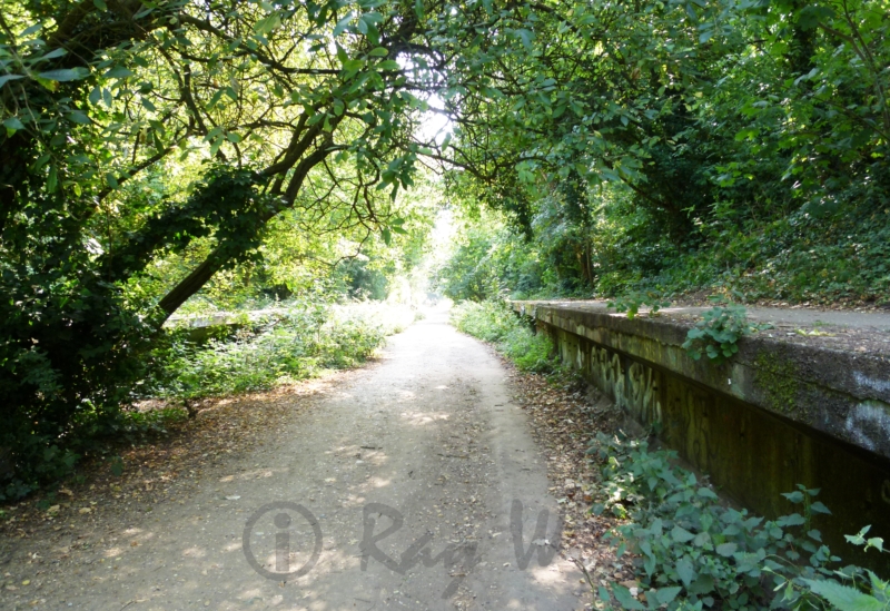
You are now following the old route of the Edgware, Highgate and London Railway. Although there is no track anymore, familiar sights can be seen including the position of a station with the platform still present.

The station - Crouch End, stopped services in 1954. It was opened in 1867 so it had a good life and now it is preserved for its nature and of course, walking.

Keep walking up - its a very slow incline and you are heading in a slightly westerly direction towards Highgate. At the very end of this section, you can make out the tunnel, which is closed at both ends. No trains these days, you are more likely to find Bats in these tunnels. At this point take a left up a steep hill to the main road - at the traffic lights take a right ( Shephards Hill) and cross over the road - walk a short distance to an alleyway on your left - walk down this to Priory Gardens.

At the bottom of the alleyway do a right and cross over the road. Still heading along Priory Gardens you will come to another alleyway on your left as pictured below.

Take this path and walk into Queens Wood. This Ancient Woodland is well worth a good look around and is in 2 sections divided by a road. From the alley go straight unless exploring until you hit Queenswood Road - cross this and find an entrance to the other section of woodland. More exploring here- great fun for children of all ages. In this section go straight again and find the frog pool then left towards the corner of the wood and the main entrance. Here, you can grab a rest in the cafe.


I've made the last image above the exit - look for this and you can see the next point of interest on the far side of the road. The street is Muswell Hill Road and this requires crossing for the entrance to Highgate Wood. This is larger and busier than Queens Wood and has many routes through it.

You can make up your own route through the wood but head over to Cranley Gate in the North-East corner. At this gate you'll be leaving the park behind. Exit onto Muswell Hill Road again and do a left - you'll see a bridge - keep left and follow the path under it.


Going under the bridge you enter the northern section of Parkland Walk. This is similar to the southern section although some great views over the rooftops of houses in Muswell Hill.

You can make out the television mast at Alexandra Palace - that is where the trail is heading. Look right at this point and over the buildings you can make out the skyscrapers of the city in the distance. Carry ambling along the path and eventually, you'll come to a brightly coloured bridge which you should go under.

The footpath will take you up and into Alexandra Palace Park. From here there is lots to explore including top views of London. The palace was opened in 1875 and cost just over £400k - astonishing where you think about - however, that's about £40m these days. In 1935 it was loaned to the BBC for transmission of news services. Currently, it is being (partly) renovated but hosts live concerts and dance parties.


From here it's a nice stroll downhill to Alexandra Park station. However, there are many other bus stops etc that will take you where you need to go.

I hope you like the walk - please see below for other trails in and around London.

Tuesday 4 August 2020

London Hikes - Walthamstow Wetlands Loop

It's important to check the opening times of the wetlands before planning this hike. However, there are many other options in the area, should the park be closed. Here's a link to the Walthamstow Wetlands website - https://walthamstowwetlands.com/ .  Here's a link to the route which is viewable on the Garmin Connect website - https://connect.garmin.com/modern/course/39066733.


This is a flat route with no difficulties. Wheelchair users note there is a bridge to push over and one section of round ground which may not be suitable. Please note no dogs are allowed in the Wetlands Park - although fine along the towpath and connecting parks.
Start by getting a Tube to Tottenham Hale on the Victoria line. When you exit the station turn left along Ferry Lane. After a few minutes walking, you'll get to the bridge by Tottenham Lock. Go down to your left (if you are on the left side of the road) then go under the bridge. The river is the Lee Navigation which stretches down from this point to the River Thames at Limehouse.


You are soon away from the busy main road and pass under a railway bridge which supports the London Overground. There are lot's of waterfowl in the area and here on the river bend, you might see the Grey Heron which hangs out for food from the neighbouring houses. When you pass under a second railway bridge you'll see the entrance to Markfield Park on the right.


At Markfield Park you can take a small diversion to check out the Markfield Beam Engine and Museum (https://www.mbeam.org/) There is also a cafe in the park.
Carry on walking in the same direction - east. You'll pass many brightly coloured narrowboats on the way - a nice area to get some photos. Along with the narrowboats, you may well see some rowing teams. When you get to the Lee Rowing Club you'll see a footbridge on your left - this needs crossing. There are a few steps to navigate if you have a wheelchair.
View below is from the bridge looking west, to where you have come from.


Once you have crossed the river you will lose sight of it for a while. Follow the track until you reach a turning left or right.  Follow it round to the left towards a low railway bridge.  Don't go under the bridge, instead, go right into the field and walk diagonally through the centre. This is Walthamstow Marsh - worth noting that in the winter and spring, this can flood. If it is flooded, go under the low bridge instead, this leads to the Walthamstow Wetlands entrance. Wheelchair users may prefer this route.
However, most year-round the marsh can be crossed easily and is firm underfoot. When you get through you'll pass an open gate and under another railway bridge to your left. Here the trail gets rough with loose pebbles underfoot. When you get to the footbridge on your right, turn left and follow the path at a right angle. Make another left at the end and you'll head down a tarmacked path with Blackberry Bushes on either side. Eventually after going under a couple of bridges you'll end up at the low bridge, this time on your left. There is a car park here and you'll need to turn right and walk over to the (rear) entrance of Walthamstow Wetlands. 


The Wetland is a collection of large reservoirs made into a nature reserve. Thousands of birds live and migrate here. There are many routes you can take through - see the map for more details but basically follow your nose through in the same direction along the lakes and pylons. Waterfowl include Swans, Egyptian Geese, Grey Heron and the wonderful Tern. There are many species of duck found here too. As said at the top of this blog, make sure you check opening time before you visit.


Look out for the Engine House with its distinctive chimney, this is a nice place for a coffee and a rest at the end of the walk. However, if you prefer a pint, leave the park to Ferry Lane and find the Ferry Boat Inn on the other side of the road. From the Ferry Boat, you can find your way back to Tottenham Hale Tube for your trip home.
I hope you have enjoyed this read and you get to try the walk - please have a look through my blog for some other trips around London.


Friday 3 July 2020

London Hikes - Bishop's Stortford to Sawbridgeworth

This beautiful walk is along the banks of the River Stort in Hertfordshire just north of London. According to my notes, the trails is 8.64 km long which is just over 5 miles.  The ground is flat but not paved and may not be suitable for regular wheelchairs.  See my record of the walk here > https://www.strava.com/activities/3701844920 .


Take the train to Bishop's Stortford railway station - get a return even though you will not travel back from this station. Leave the station through the car park and head to the metal steps to your left.  When you get to these steps you will see they bridge over the river, however, do not cross, go left here along the towpath.

Metal Step Bridge - Bishops Stortford

This section of the 'river' is called the Stort Navigation and is clearly a canal. The actual river is about 24 miles long and leads into the Lee in north London and finally the Thames at Limehouse. Carry on the left of the river as you walk south until you reach an intersection with a road. Cross the road and the path will continue through a signposted entrance on your left.  The trail has now crossed the canal and you are walking on the right of it.


The leafy surroundings create small tunnels which the narrowboats travel through. This is especially visible in the summer, when I walked the route though I enjoyed it so much I'll be going again in the winter.  There are many views and moments to capture if you have a camera, lots of sidings too that take you off in different trails on nature walks and reserves.
When you get to South Mill Lock 1, cross over using the small bridge and carry on down the left of the river.


A couple of walks to mention are Rushy Mead Nature Reserve - a small quiet location. And Thorley Wash Nature Reserve, as I understand it these are bird sanctuaries and no dogs are allowed on walks in them. Not long after Rushey Mead Nature Reserve you will need to cross another road - this is Pig Lane. Here you will keep to the left of the canal.


Very popular with canal boats, you'll find a few marinas along this section. Make sure you are looking left and right, there is plenty to see and people to say good day too. After Pig Lane the countryside opens up to ploughed fields and meadows. Before long you'll come across Thorley Wash which is over a white bridge on the opposite side of the water. At this point, you are over halfway to Sawbridgeworth.


On this occasion, I didn't visit the Wash Meadows but I would advise if you are a keen bird watcher. As the canal twists and turns, you'll pass farms and hills to the left and right.  There are lots of locks on this walk which are always good stopping points.


So finally, you'll come to a road which you 'can' pass under. This is the point where you can end your walk as you are in the town of Sawbridgeworth and a left turn and 2 minute walk will get you to the station. However, you can carry on to Harlow and or Roydon which are further down the line and both have stations on the same line.


I hope you enjoy this walk - feedback is welcome, please look through my other London based hikes in easy reach of the capital.


Monday 19 June 2017

London Hikes - Amersham Loop

A view of Amersham town at the start of the walk.
This beautiful hilly walk takes you around the south and west of Amersham and then back. I measured it at 19.3 km or about 12 miles in old money.

Thursday 15 June 2017

London Hikes - Putney to Richmond

3 hikers making their way through Richmond Park
This fantastic rural walk gives you plenty of scope to explore and makes its way through 3 areas of beauty in south west London. The walks starts at the Green Man in Putney - there are a number of bus stops here - 14, 37, 85, 493, 639, 670 and the one I caught from Victoria - the 170.  Putney rail station is approximately half a mile away as an alternative.

Saturday 10 June 2017

London Hikes - Oak Trail Theydon Bois


This walk is a nice and easy loop although some navigation skills could be required if you follow my trail to the letter.  However, there are main paths to stick to which get you round but without some great views which I will take you through now.

Sunday 28 May 2017

London Hikes - Chess Valley


As you can see from the route (above) the route of this walk runs from Chesham to Rickmansworth. Obviously you can do this in either direction - I hiked from Chesham - however, I would say starting from Rickmansworth is the better option.

Thursday 25 May 2017

Dover for the weekend..


Jamie looks for France and we saw it too.
So I had my teenage nephew (Jamie) to look after for the weekend - he likes walking (thankfully) so I decided on Dover. It has the cliffs - obviously, and a castle too. I've never been to Dover apart from on a school trip to France so the experience would be new to both of us.  We have no car so to the train station...

Wednesday 17 May 2017

Italy part 7

last stop Turin..
Pic - sunset over Bobbio

Well I have had a great time and some wonderful memories to take back with me to the UK. Let me go over the last few days since my last update. I reached Bobbio after a 5 hours drive through the mountains - I must admit I was surprised how few stops I made to take photos - on top of that it rained just after my arrival

Sunday 14 May 2017

Italy part 6

Pic - viewing Florence from Michelangelo Square
Into the mountains!
Hi - it's May 14 now so let me backtrack a bit and go over the few days since my last update. Florence was a pretty amazing place - I'm not really into city's as I have told you but this had it all and was able to be done in a day.

Thursday 11 May 2017

Italy part 5

Pic - inside Duomo di Siena

May 9. I'm currently in Sienna, and I have been here for 2 days.. Tuscany is everything I expected, beautiful rolling hills and ornate trees lining roads - almost every house is worth photographing. There are olive groves and vineyards, farm lands and just everything fits like it had been placed there.

Monday 8 May 2017

Italy part 4


When in Rome...
Pic - tourist taking a photo of St Peter's Basilica from a bridge on the Tiber.

It's my last evening in Rome - tired legs and feet - I'm having a rest, and it's well earned. I've been busy for the last two days and I've given the car some well earned rest.  In Rome they have the Metro which is an underground train that takes you around the city - only two lines though. There are plenty on other modes of transport including Tram. Bus, Boat and a good number of more tourist options.

Saturday 6 May 2017

Italy part 3


A couple of days have passed so I thought I'd write down some notes. Firstly Naples or Napoli - I decided it best to get the train in from my hotel in Caserta and see the city from my feet.  I finally got to Central Station because the first time of asking I missed the stop! So here's the news, its called Piazza Garibaldi for my train - Central Station is the level above - noted!
Pic - Piazza del Plebiscito

Friday 5 May 2017

Italy - Driving


Ok so I've decided it best I dedicate a post to driving in Italy. Now to be honest I'm a fairly aggressive driver anyway - this means I go for it rather than dither - not full of road rage! So I picked up my car at the airport in Catania - it was late and dark so I'm losing the game already..

Thursday 4 May 2017

Italy part 2

Pic - Corigliano Calabro

Moving on then I'm in my room in a place called Rossano - It's basically perched on a hill as are many of the towns / villages in these parts.  Finding your way around in a car is not easy - narrow streets and mostly one way. Still i'm here now.

Tuesday 2 May 2017

Italy part 1

Catania is a beautiful city and is seen well from the top as well as below at ground level..
Pic - Catania at sunset
Part one of Italy is complete, I'm now waiting on a ferry to the Italian mainland. This is a beautiful place but spoiled by the rubbish, it's everywhere! Today I hiked Mount Etna and there was lots of roadside rubbish on route.. Dumped stuff, it's a shame and hopefully the rest of the country will be better than Sicily, I will let you know! So Etna was the highlight for me so far, and it was good to get the hiking boots on.. plenty of photos obviously!!
Pic - Hike up a crater near Mount Etna
Yesterday was bank holiday here so I toured the island getting some shots on route, so nice seeing houses on the tops of hills and wondering how they got there.
The roads are awful too, so much so that driving is making me feel sick, not the norm! Ferry has arrived so I must dash… got to find a place to stay for one night over on the mainland.
update..
I’ve found a B&B in Palmi - hopefully get a good night's rest here and head towards Naples tomorrow - the plan (in my head) is to stay there for a few days just outside the city.  :)

More images from the trip..

https://raywise.co.uk/2017/06/06/italy-part-3/
https://raywise.co.uk/2017/06/03/italy-part-2/
https://raywise.co.uk/2017/06/01/italy-part-1/

Sunday 5 March 2017

London Hikes - Epping Forest (south)


This is a relatively short walk (8km / 5 miles) through the lower half of Epping Forest. To get to the start you will need to take the 123 Bus and get off at Beacontree Ave going north or Hillcrest Rd going south. The 123 is accessed from many Tube stops for example - Tottenham Hale, Turnpike Lane and Wood Green.

Saturday 14 May 2016

London Hikes - Dollis Valley


My Dollis Valley hike starts at West Finchley Tube, however when I walked it, the Tube was not working and I got a bus. Online you will find references to the Dollis Valley Greenland walk - this is part of my trail but starts over near the M1. All my route is recorded by GPS and saved on Strava HERE.  This trail is about 10 miles long.


From the station find your way to Dollis Brook - which runs alongside the Golf Course at the end of Fursby Ave. At the end of the golf course you need to tackle the B1462 for a very short distance - however here is an interesting point on the walk - Dollis Hill Viaduct. Worthy noted as the highest point of the Tube network standing at 18 meters tall.


From here it is easy to follow Dollis Brook as it winds its way alongside a beautiful path laden with trees and other shrubs. I saw herons and a kingfisher on the route and only a few other people out for a walk in these parts.


The walk takes you under the A1 and then under the north circular as well - both extremely busy roads and although noisy at these points it is still very rural underneath on the walk. Just before the North Circular the brook divides and goes on to form the Brent. We turn left at this point and follow the stream which is now called Mutton Brook.

When Mutton Brook goes under the A1 we turn right and cross Addison Way and into Little Wood, then we head toward Big Wood - there are a number of routes through here. On exiting Big Wood you are in Hampstead Garden Suburb. It's a beautiful place and if you want to read more please click HERE. In a nutshell, it was the invention of a husband and wife team back in 1906 although built for all classes it is really only enjoyed by the wealthy these days. A point of interest here and just of the trail is St Jude's on the hill. From here you are walking over to Hampstead Heath and all the way down it whichever way you think best.

Past the Royal Free Hospital and down Haverstock Hill you will eventually arrive at Primrose Hill with its beautiful views over London.  In my mind one of the best views of the City. You are also close to London Zoo at this point which you walk towards as the last leg of our walk takes us through Regents Park.


Lastly, then we take a stroll through Regents Park. When I walked it was May and a warm day - the trees and flowers were in full show and it was very delightful - I think this walk would also be nice in Autumn.  It is also worth noting that from the top of Hamstead Heath it is possible to get a Tube if you want to duck out (Golders Green).  But then again in London, you are never far from a Bus either. My walk finishes on Euston Rd at the exit of Regents Park - I hope you enjoy this walk as I did.

More walks found from my homepage - https://ray-wise.blogspot.com/


Friday 29 January 2016

Charity Shoot at St Paul's Cathedral


My friend Annah got in touch to do a charity shoot to raise money for not one but three charity's - Great Ormand St, Sands and Sport Relief. She got the idea when she met Dermot O'Leary while he was raising money by dancing for 24 hours - how do you beat that I asked??

Wednesday 28 October 2015

River Thames at Low Tide - a view from the foreshore.

 Autumnal Fantasy


One of my favourite places to get original images in London is the River Thames at low tide. It's a dirty, dangerous but amazing and I have been doing shoots there for quite a few years now... You certainly get a different perspective of the city from down on the foreshore. So I thought I would give a little foresight as to what makes shots like the following possible...