Friday 10 May 2024

Hoka Canyons 100 km by UTMB

After running 100k for the first time in 2022, I vowed never to do it again. However, I am a gluten for punishment and signed up for another race which takes place in Auburn, California. For extra pain, this one was mountainous taking in 3,800m of climbing and 4km of descent.  

Hello, my name is Ray Wise and I’m an ultra-runner. I have been addicted to this sport for about 12 years now and over the last few years it has gained more public attention. You are looking at running any distance over a marathon, which is 42 km (26.2 miles).  

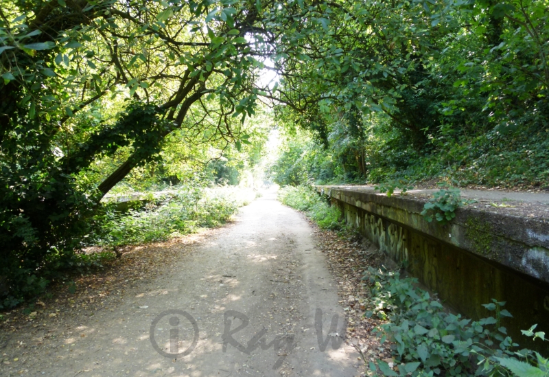
Two days before the race I hiked part of the trail so i could understand the landscape. This course is on the Western States Trail and has stunning scenery at every turn.  


So here we are in Auburn USA, I’m picking up my number and extra’s at the ‘expo’. I’m also dropping a bag with some bits to change at the halfway point (50k). There is a buzz around town and everyone is talking about the race(s). There are 4 distances to choose from, 21km, 50km, 100km and 100 miles. 


Friday was a rest day and I had an early night – the coach to the start was at 03:30 and I had to be up at 2am! Our race started at 5am with an hour or so drive, so everything needed to be ready. 

With a mix of excitement and nervousness I jogged over to the start line – toileting had been done, bag was packed, headtorch switched on as we counted down to the off. It was cool but not cold – very dark but noisy with people chatting, filming and music in the background. The elevation at the start line is just over 1,500m (5000ft). 

When the hooter sounded, I was about 10 rows back from the line – about 1000 people were in my race and we all jogged over the start line and followed a mass of headtorches towards the forest. I did not want to move too quickly but as the first 8km was downhill, but I could not help myself pick up some speed.


Daylight was breaking as we climbed out of the valley and up to Devils Thumb – our first big climb and first walk / jog.  

The next part was a loop – down a steep long hill to Swinging Bridge and then back out and up the same way – this was most certainly the hardest part. However, I had my running poles with me and used them to my advantage. Getting to the top required a lot of effort but now I was about 25km into the race – the time had quickly ticked by and the sun was having a big effect.

I started to feel over tired as my jet lag was catching up on me – I started to move a lot slower and mentally this was getting tough. Especially as now I was slowly going downhill, and we had only covered about 30km (19 miles). I slowly pushed through this awful feeling and made my goal the next aid station (number 6). When I got there I refuelled and took my time, this improved my morale. The volunteers were amazing filling up my bottles for me – they could see I need assistance. I was very grateful before I made my way off. I had hiked this section only a couple of days before so I knew what to expect. Again, I took it easy but felt a lot more comfortable now and the next stop was Forest Hill, the halfway point. 

Arriving at Forest Hill was incredible – lots of people lining the road cheering on us weary runners. And my drop bag awaited me – a change of socks and insoles made me feel fresh. And I left the running poles as most of the serious hills had ended. After 15 minutes or so I picked myself up and started the second half of the course. And now I was running again and feeling inspired – how long would that last in the midday heat? 

It lasted about 3 miles which meant I had 5 miles to push through until the next aid station. Walking / jogging and a little running came next – I overtook and got overtaken by others and had a chat and some encouragement. This worked well and before long I arrive at Cal2 aid station for more refuelling. At this stage the distance travelling was about 60km (37 miles). You tend to ignore the distance and just get your head down and move. There was a further 15km until the next stop but the sun was low now and the air was cooler – this made going a lot easier. However, it would not be long before the sun set.  


I reached the next stop (Drivers Flat) after a big climb and 75 km (46 miles) of running- the welcome was huge, lots of people supporting as well as aid station volunteers. After eating a lot of salty food and some sugar, I was ready to move on. It was to be a fairly level section but still 13km (8 miles) of running. My aim was to get to that point before it got dark. With a mix of walking and jogging, I just managed it. Some people around me were quite ill at this stage – in a bad way with their stomach’s. I was in auto mode now as we were only about 12km (7 miles) from the finish. From Mammoth Bar we climbed up and out of the valley – headtorch was on and darkness prevailed. I only met a few people over this section and conversation was very light when I did. Finding the road meant a lot as I circled a bridge and strolled into the last aid station “Confluence”. I did not hang around long – my energy was up and onward I jogged towards Auburn town centre and the finish. 


We dropped down from the road and followed a trail around to Robie Point where we took on one last but annoying climb into Auburn. A jog turned into a little run as the finishing line approached and happiness swept over me as I crossed it. The medal and memories were mine forever, pain is temporary, everything else stays with you. 

After picking up the bags and then my car I made it back to the hotel where it was now midnight. I had covered the course in 17 hours and 30 minutes – covered 3,800m of climbing (12,467 feet) and burnt more calories than I could eat. Sunday was going to be a restful one but catching up on some nutrition... 

YouTube link : HERE

Friday 3 November 2023

Istria 100 by UTMB - my 2023 experience.

A quick introduction then before I get into the race. I did not start running until I was 40 – having asthma all my life, this put me off strenuous exercise. However, a friend and I entered the London Marathon on a whim, and I was on the slippery slope from then on. After a few weeks training my chest improved and the asthma issue went away 😊 .

My first competitive Ultra- Marathon was the Marathon des Sables in Morocco – I had to litterly limp over the line. You would think that would put me off, but I continued my passion and in 2021 completed running all the London Underground Lines. Locally I’ve enjoyed running at both ultra’s which the Camino Team organise – meeting these guys has been very inspirational. I’ve volunteered for them to show my appreciation for what they do, and throughout my running career I’ve managed to raise nearly £20k for various charities which I am very proud of.

So what next? When a friend suggested I enter Istria 100 by UTMB I was a little nervous, after all, UTMB is considered (in my opinion) to be the highest of Ultra Running organisations. And with completion you may register for the world finals in Chamonix. Now let me get one thing straight here, I’m no speedster by far but I do enjoy trails. I entered, why not.


The Istra 100 is a collection of races to choose from, 168k, 110k, 69k, 42k and 21k. All with varying amounts of elevation. I have run 100k before but considering this would be my first mountain marathon, I plumped for the 69k race which has 2,200m of ascent. The race was to take place April 2023 in Croatia, so there were lots of things to organise.

I booked and flight and accommodation in nearby Strujan Slovenia – a short 20 minute drive from the finish in Umag, Croatia. I decided to have a week over there stopping a few locations to enjoy the country. With a hire car booked and everything set I was raring to go a month before, in March 2023. Lots of long runs over hills and trails made a perfect platform for the race. However, a few weeks before my flight I had problems with my feet, panic set in, and I stopped my training runs. The diagnosis was plantar fasciitis an uncomfortable feeling on the underside of your feet. This was a new injury for me and I was worried about the race and if was going to bail or not. I took every bit of advice available, and I thank my friends for that. When I boarded the plane to Slovenia, I had not run for 3 weeks but my feet were in a better place.


So, it was a careful training run I had in Strujan when I arrived at my race base. There was some discomfort, so I changed the insoles – the next days run went well and it gave me lots of encouragement. After the run I drove to Umag, went to register, pick up my race number and bag etc. Received was my race number, pins, bag drop bag, technical t-shirt, course map, bottle of beer and large hiking waterproof duffle bag – impressive. At registration everyone was very kind and helpful, there was also a few stands from the sponsors where you could purchase some of their products. I booked my place on a coach which was to take me to the start in Bezet, first thing in the morning.
Equipment – each race has its own equipment list but for mine, I was required to carry:
  • Running vest (or rucksack)
  • Mobile phone (with LiveRun app. If phone has the ability)
  • Soft Cup (bottles / flasks no accepted)
  • Min water supply 1 litre. In flasks or bottles etc
  • 1 working headlamp
  • Survival blanket 1.4m x 2m min.
  • Whistle
  • Self-adhesive bandage or strapping
  • Food reserve approximately 800kcal
  • Jacket with hood for bad weather in the mountains. The jacket must be made with a waterproof (minimum recommended 10 000 Schmerber) and breathable (RET recommended inferior to 13) membrane (eg. Outdry)
If severe weather is expected the organisers can ask for extra items such as sun hat or leggings etc.Each year these rules may change so it is worth checking the organisers website for up-to-date information.
Race day – I was very excited and had a special breakfast organised by the hotel at 5:30am. Checked my kit twice (don’t forget the bucket hat)and after the standard loo trip, drove over to Umag and found a parking spot. The excitement built as I met some fellow runners, and we swapped the usual running stories and I started to feel a lot more relaxed. The coaches left at 07:15, there were about 10 coaches all full of runners – very well organised. We arrived in Buzet in plenty of time and a nearby café was on hand with toilets and drinks etc.
I purposely hung back at the start as I thought there would be a mad rush and I didn’t want to get caught up in it. What I did not prepare for was the mud and slime caused by the rain we had a few days before. Too late for a shoe change – just live with it! The plan was to power-hike up all the hills and run the rest. The mud made it difficult with a lot of sliding even on the downhill which I took cautiously. After 17km or so I arrived at the first aid station. Fill up the bottles – one with water, the other with isotonic drink. Lots of food on offer of all designs – sweet and savoury. For me, this was a quick stop before carrying on. The feet felt fine – no sign of the injury so my confidence was high and texts from my friends kept up my morale.


At about 30km I climbed the cobbled trail up to Motovun – a lovely town perched on a hill, and what a hill! But the power-hiking was working, giving me the rest I needed to control my heartrate. By checkpoint 2 at 32km my clock was at about 4 hours and I’d ascended about 1,300m. I had also discovered some other runners who were around me at any given time. It was about here that one of my friends told me I was in third place for my age group (55-58). This was a shock but also a confidence boost as I was unprepared for any accomplishment other than finishing!


At around 5 hours and 50 minutes I completed 42km and that’s marathon distance. The mud dried up and I was able to find my running feet. The nutrition was working well – sticking to what works and avoiding what doesn’t. The last big hill was beckoning before checkpoint 3 and from then on was fairly all downhill into Umag. 47km and checkpoint 3, I rested for about five minutes taking on lots of sugar – refilled my soft flasks and received another text. You are now 2nd in your age group! Wow, and what the flip? Ok, what’s the plan now? So everything changes when you are in a race – I’d never been in this position before but decided to give it a go – what’s to lose, right?
Out of CP3 it was flat and long as we crested the hills outside Groznjan. This was tiring and hard work but I had the motivation now. Having a slow first part of the race helped with the second, I suddenly found my energy as the downhill started – checkpoint 4 was a quick refill and go – I’m racing now and overtaking runners from the other races, which raised my confidence again. At CP4 the distance is 55km and now we are looking at downhill all the way in – just 14km to go – a training run?


My legs were working well now by pace had increased by minutes and I was overtaking dozens of people. Before long after a flat farmland, I was entering the town of Umag and some onlookers were cheering, the sun was out and the end was in sight. Nothing else was on my mind apart from the joy and gratefulness of completing another race. I’ve actually completed a UTMB race – I’m thinking, hmm, I’m hungry and wondering what beer I’ll have at the finish. The crowds get busier as I close in on the line nothing can stop me now! I’m done, and the medal is placed around my neck after crossing the line – elation is there for all to see with congratulations from fellow runners.


After a few minutes I had another text from my friend in the UK – you actually won your age group! Ok, this needs checking, someone must have got something wrong. And with that, a couple of friends appeared from the crowd issuing me with the same information – you did amazing, you won your age group. What just happened? I’m caught between joy and embarrassment. The 58 year old finally wins a race and its because he’s old – kind of comical hey?

The next day I was invited to the award ceremony at the finish line in Umag – in the 100 mile race, Jim Walmsley won, so it was inspiring to see him on stage before the likes of me. On a personal level achieving a first for my age group was something I’ll never forget. The course was something else, some parts were outstandingly pretty, some were fairly unattractive. The organisation was first class, from beginning to end I could not have asked for a better service. And I’ll be entering myself for the finals in 2024 so this is not the end of the story. On running races, my advice would be pick one abroad and turn it into a holiday – you’ll not regret it.

Route, heart rate and timings etc - STRAVA


Sunday 9 August 2020

Parkland Walk including Finsbury Park, Queens Wood, Highgate Wood and Alexandra Palace

 This point to point walk is about 5 miles in length and not suitable for wheelchair users. There are no restrictions for dog walkers on this walk as far as I am aware. My recording starts you off at Finsbury Park station and ends up at Alexandra Park station. This walk is all uphill but is slow to climb, however, if you do it in reverse you will start with a steep uphill challenge.

Route - Garmin

Once you have explored Finsbury Park - head over to the west side where the Tennis Courts are. Here, there is a footbridge over the railway. Take this bridge and take a sharp right afterwards and head up the tree-lined pathway. This is Parkland Walk South

You are now following the old route of the Edgware, Highgate and London Railway. Although there is no track anymore, familiar sights can be seen including the position of a station with the platform still present.

The station - Crouch End, stopped services in 1954. It was opened in 1867 so it had a good life and now it is preserved for its nature and of course, walking.

Keep walking up - its a very slow incline and you are heading in a slightly westerly direction towards Highgate. At the very end of this section, you can make out the tunnel, which is closed at both ends. No trains these days, you are more likely to find Bats in these tunnels. At this point take a left up a steep hill to the main road - at the traffic lights take a right ( Shephards Hill) and cross over the road - walk a short distance to an alleyway on your left - walk down this to Priory Gardens.

At the bottom of the alleyway do a right and cross over the road. Still heading along Priory Gardens you will come to another alleyway on your left as pictured below.

Take this path and walk into Queens Wood. This Ancient Woodland is well worth a good look around and is in 2 sections divided by a road. From the alley go straight unless exploring until you hit Queenswood Road - cross this and find an entrance to the other section of woodland. More exploring here- great fun for children of all ages. In this section go straight again and find the frog pool then left towards the corner of the wood and the main entrance. Here, you can grab a rest in the cafe.


I've made the last image above the exit - look for this and you can see the next point of interest on the far side of the road. The street is Muswell Hill Road and this requires crossing for the entrance to Highgate Wood. This is larger and busier than Queens Wood and has many routes through it.

You can make up your own route through the wood but head over to Cranley Gate in the North-East corner. At this gate you'll be leaving the park behind. Exit onto Muswell Hill Road again and do a left - you'll see a bridge - keep left and follow the path under it.


Going under the bridge you enter the northern section of Parkland Walk. This is similar to the southern section although some great views over the rooftops of houses in Muswell Hill.

You can make out the television mast at Alexandra Palace - that is where the trail is heading. Look right at this point and over the buildings you can make out the skyscrapers of the city in the distance. Carry ambling along the path and eventually, you'll come to a brightly coloured bridge which you should go under.

The footpath will take you up and into Alexandra Palace Park. From here there is lots to explore including top views of London. The palace was opened in 1875 and cost just over £400k - astonishing where you think about - however, that's about £40m these days. In 1935 it was loaned to the BBC for transmission of news services. Currently, it is being (partly) renovated but hosts live concerts and dance parties.


From here it's a nice stroll downhill to Alexandra Park station. However, there are many other bus stops etc that will take you where you need to go.

I hope you like the walk - please see below for other trails in and around London.

Tuesday 4 August 2020

London Hikes - Walthamstow Wetlands Loop

It's important to check the opening times of the wetlands before planning this hike. However, there are many other options in the area, should the park be closed. Here's a link to the Walthamstow Wetlands website - https://walthamstowwetlands.com/ .  Here's a link to the route which is viewable on the Garmin Connect website - https://connect.garmin.com/modern/course/39066733.


This is a flat route with no difficulties. Wheelchair users note there is a bridge to push over and one section of round ground which may not be suitable. Please note no dogs are allowed in the Wetlands Park - although fine along the towpath and connecting parks.
Start by getting a Tube to Tottenham Hale on the Victoria line. When you exit the station turn left along Ferry Lane. After a few minutes walking, you'll get to the bridge by Tottenham Lock. Go down to your left (if you are on the left side of the road) then go under the bridge. The river is the Lee Navigation which stretches down from this point to the River Thames at Limehouse.


You are soon away from the busy main road and pass under a railway bridge which supports the London Overground. There are lot's of waterfowl in the area and here on the river bend, you might see the Grey Heron which hangs out for food from the neighbouring houses. When you pass under a second railway bridge you'll see the entrance to Markfield Park on the right.


At Markfield Park you can take a small diversion to check out the Markfield Beam Engine and Museum (https://www.mbeam.org/) There is also a cafe in the park.
Carry on walking in the same direction - east. You'll pass many brightly coloured narrowboats on the way - a nice area to get some photos. Along with the narrowboats, you may well see some rowing teams. When you get to the Lee Rowing Club you'll see a footbridge on your left - this needs crossing. There are a few steps to navigate if you have a wheelchair.
View below is from the bridge looking west, to where you have come from.


Once you have crossed the river you will lose sight of it for a while. Follow the track until you reach a turning left or right.  Follow it round to the left towards a low railway bridge.  Don't go under the bridge, instead, go right into the field and walk diagonally through the centre. This is Walthamstow Marsh - worth noting that in the winter and spring, this can flood. If it is flooded, go under the low bridge instead, this leads to the Walthamstow Wetlands entrance. Wheelchair users may prefer this route.
However, most year-round the marsh can be crossed easily and is firm underfoot. When you get through you'll pass an open gate and under another railway bridge to your left. Here the trail gets rough with loose pebbles underfoot. When you get to the footbridge on your right, turn left and follow the path at a right angle. Make another left at the end and you'll head down a tarmacked path with Blackberry Bushes on either side. Eventually after going under a couple of bridges you'll end up at the low bridge, this time on your left. There is a car park here and you'll need to turn right and walk over to the (rear) entrance of Walthamstow Wetlands. 


The Wetland is a collection of large reservoirs made into a nature reserve. Thousands of birds live and migrate here. There are many routes you can take through - see the map for more details but basically follow your nose through in the same direction along the lakes and pylons. Waterfowl include Swans, Egyptian Geese, Grey Heron and the wonderful Tern. There are many species of duck found here too. As said at the top of this blog, make sure you check opening time before you visit.


Look out for the Engine House with its distinctive chimney, this is a nice place for a coffee and a rest at the end of the walk. However, if you prefer a pint, leave the park to Ferry Lane and find the Ferry Boat Inn on the other side of the road. From the Ferry Boat, you can find your way back to Tottenham Hale Tube for your trip home.
I hope you have enjoyed this read and you get to try the walk - please have a look through my blog for some other trips around London.


Friday 3 July 2020

London Hikes - Bishop's Stortford to Sawbridgeworth

This beautiful walk is along the banks of the River Stort in Hertfordshire just north of London. According to my notes, the trails is 8.64 km long which is just over 5 miles.  The ground is flat but not paved and may not be suitable for regular wheelchairs.  See my record of the walk here > https://www.strava.com/activities/3701844920 .


Take the train to Bishop's Stortford railway station - get a return even though you will not travel back from this station. Leave the station through the car park and head to the metal steps to your left.  When you get to these steps you will see they bridge over the river, however, do not cross, go left here along the towpath.

Metal Step Bridge - Bishops Stortford

This section of the 'river' is called the Stort Navigation and is clearly a canal. The actual river is about 24 miles long and leads into the Lee in north London and finally the Thames at Limehouse. Carry on the left of the river as you walk south until you reach an intersection with a road. Cross the road and the path will continue through a signposted entrance on your left.  The trail has now crossed the canal and you are walking on the right of it.


The leafy surroundings create small tunnels which the narrowboats travel through. This is especially visible in the summer, when I walked the route though I enjoyed it so much I'll be going again in the winter.  There are many views and moments to capture if you have a camera, lots of sidings too that take you off in different trails on nature walks and reserves.
When you get to South Mill Lock 1, cross over using the small bridge and carry on down the left of the river.


A couple of walks to mention are Rushy Mead Nature Reserve - a small quiet location. And Thorley Wash Nature Reserve, as I understand it these are bird sanctuaries and no dogs are allowed on walks in them. Not long after Rushey Mead Nature Reserve you will need to cross another road - this is Pig Lane. Here you will keep to the left of the canal.


Very popular with canal boats, you'll find a few marinas along this section. Make sure you are looking left and right, there is plenty to see and people to say good day too. After Pig Lane the countryside opens up to ploughed fields and meadows. Before long you'll come across Thorley Wash which is over a white bridge on the opposite side of the water. At this point, you are over halfway to Sawbridgeworth.


On this occasion, I didn't visit the Wash Meadows but I would advise if you are a keen bird watcher. As the canal twists and turns, you'll pass farms and hills to the left and right.  There are lots of locks on this walk which are always good stopping points.


So finally, you'll come to a road which you 'can' pass under. This is the point where you can end your walk as you are in the town of Sawbridgeworth and a left turn and 2 minute walk will get you to the station. However, you can carry on to Harlow and or Roydon which are further down the line and both have stations on the same line.


I hope you enjoy this walk - feedback is welcome, please look through my other London based hikes in easy reach of the capital.